neighborhood design

Work in Progress: Warren Park – Northwest Arkansas Newest Mixed-Use Neighborhood

An integrated stormwater canal within the North neighborhood of Warren Park. Dover, Kohl & Partners, 2022

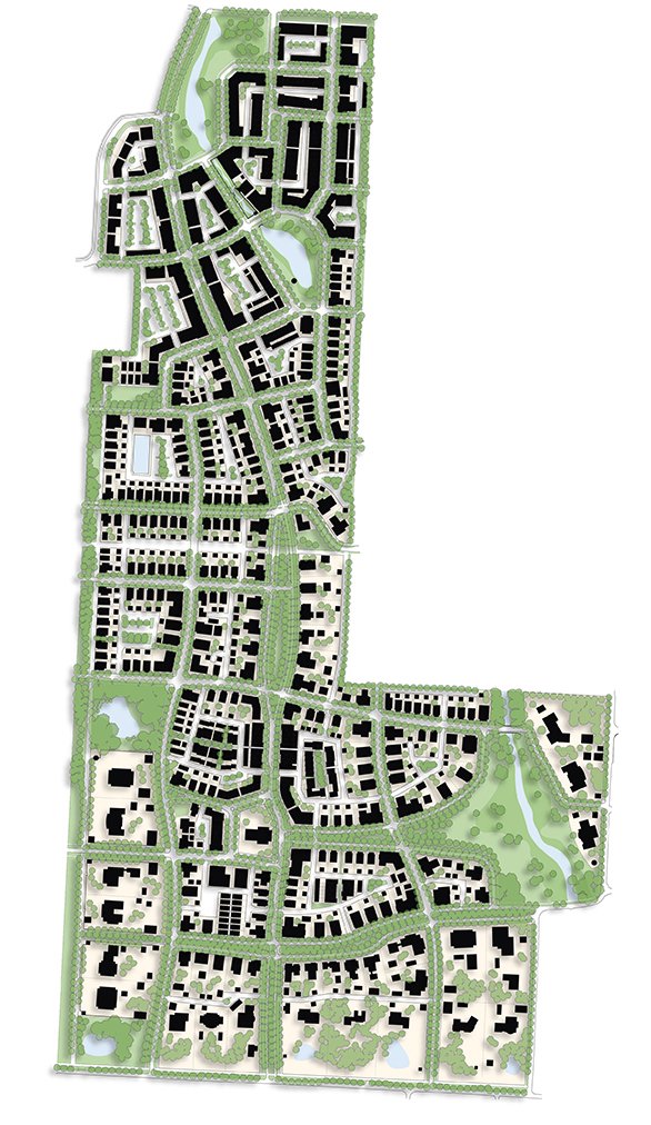
Warren Park Illustrative Plan

A subtle slough wandering through the hay bales, a vast and dancing meadow of wildflowers, and a perfectly pale blue Arkansas midday sky met the Dover, Kohl & Partners team as they first started laying out the future for 197 acres of Northwest Arkansas pastureland. The Warren Family farm’s natural charms and connectivity to Rogers, Bentonville, and the Razorback Greenway together make for fertile grounds in planning the next great NWA community.

The Dover, Kohl & Partners-led design is essentially two, five-minute neighborhoods large – one North and one South – taking advantage of the existing topography and canopy to create accessible urbanism for a wide variety of households and businesses interlinked through public space.  This “Village of Gardens” is inspired by the many great historic American planned neighborhoods of the early 20th Century and their European originations. Places like Mariemont in Ohio and Forest Hills Gardens in New York with their view-framing street deflections and grand public greens or the classic architecture of the Cotswolds and Bath that inspired them in turn. These examples create the foundation for settling a town in the rolling foothills of the Ozarks and are just as relevant to Bentonville as they are Bruges with a strong organization around site context and architectural regionalism.

View from the boutique hotel balcony toward the canal biergarten and event space

Both neighborhoods of Warren Park are centered around public spaces framed with fine-grained building fabric. The northern neighborhood features the more active and commercial areas of the mixed-use program bikeable via the Razorback Greenway and a separated cycletrack. This new Main Street runs a block away and parallel to the existing shallow stream now activated and compressed with canal-front restaurants and boutique hotel rooms while expanded on either end with floodable, passive stormwater parks. The larger of the two stormwater parks lies uphill and when dry serves as a commons for the nearby community center and crescent units on its perimeter.

Grand estate lots are set near the southern neighborhood edges in Warren Park, coupling with long views in public park spaces

Curbside cycletrack along the new mixed use Main Street section of Pinnacle Hills Parkway

The southern neighborhood is centered on a traditional square – complete with a site for a place of worship, grand estate homes, and “missing middle” cottages. The central square and the church project just enough into incoming streets and the network of green spaces to be seen from several blocks away in many different directions. Estate lots on both sides of the neighborhood contain a variety of outbuildings, and on the west side of the neighborhood, face a perimeter trail. Where both the South and the North neighborhood meet, they are joined by West Street, which is designed with a third line of canopy trees shading a multi-user trail; deep front porches will face towards the bikeway.

The Dover, Kohl & Partners team is proud to introduce the plan and some of the inspiration behind it.

Several public spaces will offer unique addresses in the northern neighborhood of Warren Park

A view looking east down West Drive shows its shaded trail, a key connection to the Razorback Greenway

Every Neighborhood Should Have These Five Things

This one’s all about neighborhoods: Episode 5 of Town Planning Stuff Everyone Needs to Know reached screens Monday, May 11, 2020 via social media and our YouTube channel, and it includes some striking animations by Alex England, Kenneth Garcia, and Pablo Dueñas.

Neighborhoods are the basic building block of a city or town.

In 1929, Clarence Perry documented what he called “The Neighborhood Unit.” His classic diagram remains useful; it’s been updated several times since, including in the early 1990s by Gary Greenan and Lizz Plater-Zyberk for AIA Graphic Standards, and again in 2007 for Doug Farr’s book Sustainable Urbanism.

Clarence Perry’s “Neighborhood Unit.”

Clarence Perry’s “Neighborhood Unit.”

When you have one neighborhood standing alone among the farms or in the woods or the wilderness, that’s a village. When growth leads to several of these neighborhoods positioned tightly together, you get a town, and, with even more neighborhoods, a city. In this way, small towns and big cities like Paris or New York or Washington are all cities made of neighborhoods.

Neighborhoods: the fundamental unit of city building.

Neighborhoods: the fundamental unit of city building.

The five crucial ingredients

Neighborhoods vary a lot, but they have five basic characteristics. We keep these in mind when planning a new neighborhood or when carefully updating or restoring an existing one.

Compact, complete, connected, convivial.

Compact, complete, connected, convivial.

First, a proper traditional neighborhood has an identifiable center & edge. You know when you’ve arrived at the heart of a neighborhood; large or small, it almost always has a deliberate, consequential public space, shared by all. You will typically find a square or plaza, and a noteworthy civic building or landmark (and in the best examples, some locally-serving commerce). Edges, on the other hand, vary greatly. While historically a fortified town might have had a wall for protection, that has thankfully evolved to more inclusive and welcoming physical identifiers. The boundaries between neighborhoods might simply take the form of a mixed-use main street shared by several adjoining neighborhoods, forming a “seam” instead of a seal. Or the edge can be a greenbelt of parkland, forest or farmland, or a water body, or a transit or greenway/trail corridor, or some other feature. All that being said, centers are arguably much more important to the neighbors’ well-being than the edges; the centers are where the bonds of community are most firmly formed.

Second, the neighborhood is limited in size, about five minutes’ walk from center to edge. That’s an easy distance to navigate without driving. It’s also an amount of territory that is easily mentally mapped, committed to memory in great detail, and in an area this size people come to know many of their neighbors. Parents in traditional neighborhoods tend to allow their children greater freedom to roam for these reasons. Five minutes’ walk results in a radius of about a quarter of a mile, but that’s a rough measurement only; neighborhoods are almost never circular! Perry’s neighborhood unit envisioned idealized neighborhoods at a size of about 160 acres, but in practical application we find traditional neighborhoods range from about 40 acres to about 300 acres. Larger sites are designed as multiple neighborhoods. Although there are many ways their edges are defined physically, real neighborhoods don’t extend endlessly across the horizon.

Next, it has a mix of land uses & building types & housing types and prices. That variety allows for some of life’s basic daily needs to be satisfied within the neighborhood. (More on this coming up in Episode 7, on mixed land uses.) An old rule of thumb says, if you can buy a quart of milk within 5 minutes walk, that’s a more livable neighborhood. That’s also a neighborhood where you’re more likely to walk or bike, burning calories instead of fossil fuels. We don’t use the term “neighborhood”to describe vast, standalone precincts of a single land use, like tract house subdivisions, apartment complexes, office parks, or shopping centers. Variety in the housing types and sizes welcomes a wider range of households and income levels, making it possible to blend generations, improve inclusiveness, and to avoid socially harmful concentrations of poverty.

Fourth, the neighborhood should also have an integrated network of walkable streets. Making the streets connected, beautiful and walkable are all key to fostering a healthy culture of physical activity, making public transit viable, creating great addresses that add value to real estate, and more. (Episode 8, on the public realm, and Episode 9, on walkable street design, will cover this in more detail.)

Last, the neighborhood should have some of the best sites reserved for civic purposes, like public buildings, places of worship, parks, squares, and gathering places. These sites are the ones which are lent significance by the artfully composed geometry of the neighborhood plan itself; for example, a civic building is lent prominence by positioning it at the end of a street vista or facing a public square, communicating the importance of the shared institution inside it to the society that built the neighborhood. Public buildings and civic gathering places are crucial anchors that lend certainty in an unpredictable world, precisely because they are more permanent than the private houses or everyday workplaces— so these sites should be identified, set aside and protected from private development right from the beginning.

Neighborhoods: They’re fundamental, and they’re #5 on my list of #townplanningstuff everyone needs to know. —Victor

"Connect the Dots" virtual lecture draws huge audience

On May 4, 2020, Victor Dover delivered a “virtual lecture” for the Civic Conversations series, hosted by the Pensacola News-Journal and the Studer Community Institute. Quint Studer introduced Victor as “the Michael Jordan of urban planning” at the start of this extraordinary event, streamed live for an estimated 6000 viewers. The talk features an in-depth discussion of what makes housing expensive, and what to do about it, including how the costs of housing and transportation must be considered as a composite number, and examples of innovation from around the United States. The event concluded with a live Zoom Q&A moderated by Lisa Nellessen-Savage, executive editor of the PNJ.